Posts

Showing posts from June, 2020

The Milnerton Lagoon: Part 2

Image
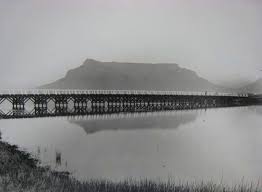
The Wooden Bridge In 1900-01, the Fortress Company of the Royal Engineers constructed a single-lane wooden bridge to give troops access to the “island” on the sea side of the lagoon, and thence up the coast. This bridge, made of jarrah (an Australian hardwood), was intended to be a temporary structure, but it is still standing to this day and is commonly known as “The Wooden Bridge”. The same Company built a similar bridge as a viaduct for the railway over the Salt River mouth, but this structure was demolished once the railway was no longer in operation.                                                                                                  The wooden bridge c. 1903 (Photo: Ravenscroft Collection)                                                                                    British soldiers exercising their horses near the newly completed bridge c.1902 When I was a boy, I used to cycle across the wooden bridge, being careful to keep to one of the beams b

The Milnerton Railway

Image
In May 1898, Milnerton Estates requested permission of the Cape Parliament to build a railway line to a terminus on Jan Biesjes Kraal. Permission was granted and in April 1899, tenders were called for the construction of the Milnerton Railway.  There was already a line heading north from Cape Town, which crossed the Salt River near Koeberg Road, but negotiations with the Cape Government Railways (CGR) resulted in a decision to link up with the existing network nearer Cape Town at Craig’s Crossing, which was a road traffic bridge giving access to the defensive fort named Craig's Tower, situated on Woodstock beach.                                                                 Blackie, the first locomotive in South Africa, crossing the bridge across the Salt River c. September 1861                                                                                    Craig's Tower and Jan Biesjes Kraal are both indicated on this sketch map of 1806 Unable to provide

The Milnerton Lagoon: Part 1

Image
The Milnerton lagoon is, in actual fact, the lower reaches of the Diep River, which rises in the Riebeek Kasteel mountains 65 km north-east of Cape Town and flows through the wheat-producing areas of the Swartland  before entering the Rietvlei wetland and then emptying into the sea at Milnerton. It has one major tributary, the Mosselbank, which drains the northern slopes of the Durbanville hills. Other tributaries include the Swart, Groen, Klein, and Riebeeck, with the Klapmuts being a tributary of the Mosselbank. The Diep River did not originally flow into Table Bay at its present outlet, but continued inland, where there was a confluence with the Salt River, thereby forming a far wider estuary than either of the rivers has today. The map below, drawn in 1656, gives a rough idea of the Diep’s original course. The arrow indicates the site of the wreck of the Nieuwe Haerlem , mentioned in a previous blog.                            The original course of the Diep River can

Wolraad Woltemade and His Horse Vonk

Image
It was a stormy winter's night in June 1773. All night the storm raged. There were five ships anchored in Table Bay, which were buffeted and pounded by the turbulent waves. Bright flashes of lightning lit up the imposing Table Mountain and the little settlement of Cape Town. Few of the sailors managed to sleep as their wooden ships creaked and groaned as they strained at their anchors. Captain Barend Lameren was alarmed when his ship, De Jonge Thomas , began to drag its anchor. There were 191 men, women and children on board his ship, along with a valuable cargo from the East. As the storm intensified, just after midnight on 1 June 1773, the captain ordered the ship's cannon fired to alert those on shore that he was in dire need of help.                                                                                                                      Original painting by Peter Baylis Shortly after 5 a.m., De Jonge Thomas broke loose from its last anchor and was

Farms, signal cannons and outspans along the West Coast

Image
While the new Dutch settlement at the Cape traded out of necessity with the neighbouring Khoekhoen, one could hardly describe the relationship as friendly, and the authorities made deliberate attempts to restrict contact. Partly as a consequence, VOC employees found themselves faced with a labour shortage. To remedy this, they released a small number of Dutch from their contracts and permitted them to establish freehold farms, on condition that they supplied only the VOC settlement from their harvests . This arrangement proved highly successful, with these farmers producing abundant supplies of fruit, vegetables, wheat, and wine; they later raised livestock. The initial small group of free burghers, as these farmers were known, steadily increased and began to expand their farms further north and east into the territory of the Khoekhoen. The VOC also established Gouvernments Plaatsen (Government Farms), which were managed by officials in its employ, and leningsplaatsen (loan farms),