The Milnerton Lagoon: Part 2
The Wooden Bridge
In 1900-01, the Fortress Company of the Royal
Engineers constructed a single-lane wooden bridge to give troops access to the “island”
on the sea side of the lagoon, and thence up the coast. This bridge, made of
jarrah (an Australian hardwood), was intended to be a temporary structure, but
it is still standing to this day and is commonly known as “The Wooden Bridge”.
The same Company built a similar bridge as a viaduct for the railway over the Salt River mouth, but this structure was demolished once the railway was no longer
in operation.
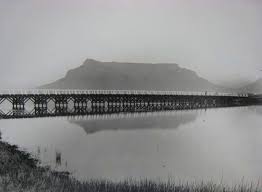 The wooden bridge c. 1903 (Photo: Ravenscroft Collection)
 British soldiers exercising their horses near the newly completed bridge c.1902
When I was a boy, I used to cycle across the wooden bridge, being careful to keep to one of the beams because the gaps between them were just wide enough for a tyre to slip through and catapult one over the handlebars. A layer of bitumen later covered these gaps. I'd also row my Indian canoe under the bridge, lying down as I inched under the cross beams.


When I was a boy, I used to cycle across the wooden bridge, being careful to keep to one of the beams because the gaps between them were just wide enough for a tyre to slip through and catapult one over the handlebars. A layer of bitumen later covered these gaps. I'd also row my Indian canoe under the bridge, lying down as I inched under the cross beams.

The wooden bridge in 1964 (Photo:Etienne du Plessis)
In 2007, the old wooden bridge was declared unfit for public use after its condition had deteriorated over the years. The City of Cape Town has a legal obligation to restore the bridge as it is a declared national heritage site and the City's budget allocation makes provision for such expenditure. In 2016, the City announced plans to spend R27 million on a contract to restore the bridge, which is the only wooden structure of its kind in the country. The restoration work took over two years, with most of the wood having to be replaced as it could not be salvaged. Now that it has been restored, the bridge has re-opened for pedestrians and cyclists.
In 2007, the old wooden bridge was declared unfit for public use after its condition had deteriorated over the years. The City of Cape Town has a legal obligation to restore the bridge as it is a declared national heritage site and the City's budget allocation makes provision for such expenditure. In 2016, the City announced plans to spend R27 million on a contract to restore the bridge, which is the only wooden structure of its kind in the country. The restoration work took over two years, with most of the wood having to be replaced as it could not be salvaged. Now that it has been restored, the bridge has re-opened for pedestrians and cyclists.

My Mom, sisters and I on the old wooden bridge c. 1961
The Concrete Bridge
An award-winning concrete bridge, built at a cost of R1,4 million in
1984, now gives vehicular access to what is called Woodbridge Island. It was completed in
a record time of four-and-a-half months from design to completion.

The Weir
A newspaper published in December 1903 includes
the following information furnished by the Board of Milnerton Estates: “Plans
are now being prepared for the construction of retaining walls and a weir
across the Diep River, with the object of maintaining the river at an average
depth of about five feet.”


The Flood
One unforeseen and potentially disastrous emergency confronted Milnerton in 1941 when, owing to some obstruction at the weir, the flood gates jammed and the entire area fronting on the lagoon was suddenly submerged, with the prospect of a real disaster to most of the town. Unable to cope with this unaided, the officials had to call in the army and the South African Engineering Corps appeared with praiseworthy speed. So urgent was the position that they were obliged to blow up the eastern section of the weir, and the accumulated waters escaped, saving Milnerton in the nick of time. The rest of the weir was subsequently removed. However, its existence is commemorated in the name Weir Road, which is in line with where the weir once stood.


Comments
Post a Comment